Maps of the Antique
Mediterranean Sea
 The Romans The Romans
 Overview Overview
 Some dates Some dates
 Archaeological sites Archaeological sites
 Roman art Roman art
 Coinage Coinage
 Language and Writing Language and Writing
 Roman Gaul Roman Gaul
 Archaeological sites Archaeological sites

|
ROMAN GAUL

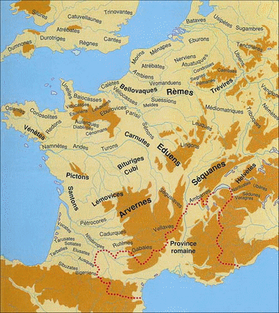
| Until its conquest by Julius Caesar, what is now France was mainly inhabited by Celtic populations. Their territory went far beyond the borders of today's France. This mosaic of various peoples without unity constituted in no way a nation, and if their civilization was far more advanced than the Roman conquerors did suggest, it can not be counted among the Mediterranean civilizations. Why do we mention it here then? Simply because ... it is our country, and lovers of archeology may meet there, in every area, remains that reveals the traces of times that were, if not Roman, at least strongly Romanized.
It were also the Romans - always prompt to rename peoples - who called "Gauls" all these Celtic populations that often threatened them and had sometimes overwhelmed them in the past. |
Narbonese Gaul
Only the Mediterranean shore was actually in contact with Mediterranean civilizations, probably first with some Phoenician trading posts, then by the 7th century BC with the settlement of Rhodian emigrants (did they named the Rhone river from their origin country?), then the Phoceans between the 7th and 4th century BC. They rarely ventured towards inland, except along the lower Rhone. They founded cities like Emporion (Ampurias) and Massalia (Marseille) - which soon dominated it - Monoikos (Monaco), Nikaia (Nice), Antipolis (Antibes), Athenopolis (Saint-Tropez), Heraclea Caccabaria (Cavalaire ), Pergantion (Bregançon), Olbia (Hyeres), Tauroeis (Le Brusc), Citharista (La Ciotat), Carcisis (Cassis) etc. Their presence was not ignored by native peoples, who probably shared with them various aspects of their culture.
The Romans frequently crossed this area without too much trouble to reach, by land, their colonies of today's Spain. On the contrary, it was not uncommon that Greek cities called the Romans for help when they felt threatened by celtic incursions. The Romans took this opportunity to turn this area into a "Roman Province" in 118 BC (hence the name Provence), which was first called Transalpine Gaul, as opposed to the "Hairy Gaul" (barbarian) which was across its northern border. Marseille was a faithful ally of Rome, and therefore kept a kind of autonomy, though Julius Caesar besieged it in 49 BC because it supported his rival Pompey, and thus its navy could have presented a risk.
The conquest
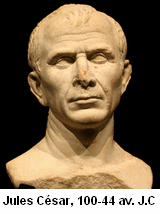
 Julius Caesar, proconsul of the province from 58 to 49 BC took advantage of such threats, making clever use of disagreements between tribes and gradually taking control of their whole territory. The attempt of Vercingetorix, which remains famous in history, was among the rare occasions where a considerable number of Gauls really united against the roman invader. After his victory, Caesar completed his conquest by annexing Massalia and its surroundings, who had assisted Pompey. Julius Caesar, proconsul of the province from 58 to 49 BC took advantage of such threats, making clever use of disagreements between tribes and gradually taking control of their whole territory. The attempt of Vercingetorix, which remains famous in history, was among the rare occasions where a considerable number of Gauls really united against the roman invader. After his victory, Caesar completed his conquest by annexing Massalia and its surroundings, who had assisted Pompey.
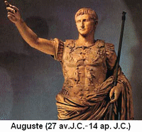
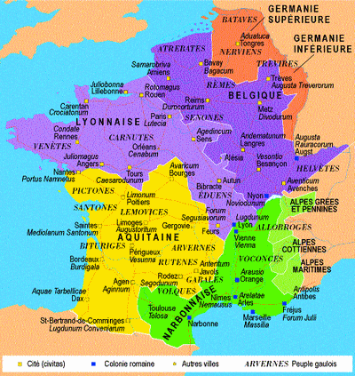
After the conquest of Gaul by Caesar and its reorganization by Augustus in 22 BC, the Province was renamed Narbonese (Narbonne being its capital), and three different areas under Roman control were defined:
 | - Aquitania Gaul, the land located west of Narbonne.
- Lugdunesis Gaul, located approximately between the Loire and the Seine.
- Belgic Gaul, located north of a line joining the Seine river to the lake of Geneva, and reaching the Rhine in the north.
In addition, two Roman provinces (lower Germany and upper Germany) were created as a "buffer" between the Roman world and the Germanic tribes, which remained undefeated. Last, on the other side of the Channel, were the Britons. |
Roman Gaul
 During the Roman Empire, Romans settled permanently in the country, but we must not imagine an "occupation" like in modern times. As they had done elsewhere and without harassing people, they built up an administration and infrastructure that native people accepted willy-nilly, with occasionally some revolts. Roman camps became Roman cities connected by a network of roads as required for communication thoughout the Empire. Urbanization occured according to the classical Roman cities map, a rectangular plan divided into four quarters by two perpendicular main streets (Decumanus Maximus and Cardo Maximus), equipped with everything Romans needed, including a forum, basilica, theater, amphitheater, baths and, of course, water supplied by aqueducts During the Roman Empire, Romans settled permanently in the country, but we must not imagine an "occupation" like in modern times. As they had done elsewhere and without harassing people, they built up an administration and infrastructure that native people accepted willy-nilly, with occasionally some revolts. Roman camps became Roman cities connected by a network of roads as required for communication thoughout the Empire. Urbanization occured according to the classical Roman cities map, a rectangular plan divided into four quarters by two perpendicular main streets (Decumanus Maximus and Cardo Maximus), equipped with everything Romans needed, including a forum, basilica, theater, amphitheater, baths and, of course, water supplied by aqueducts
In short, everything that could render the familiar environment of a Roman of the time... and impress the local inhabitants. We have to recognize that the Romans were indefatigable builders, and they built well. Thus they left us a rich archaeological heritage of impressive monuments, some of which keeping an extraordinary state of preservation after 2000 years of existence.
Materially, many small votive or daily life artefacts were found, and are sill found each year nowadays, in all areas, like coins that were lost or hidden during unsecure times. And sometimes appears a major work, such as imperial statues. Many Roman villas have been identified, some large farms, and sometimes entire cities. Archaeological sites abound, with today a "site museum" when findings were particularly rich.
Most historical local, regional or national museums include Gallo-Roman collections which are worth a visit. You may find more information about them in our section "Gallo-Roman Archaeological Sites" and our chapter "Museums".
|


